Highway H10 (Ukraine)
Appearance
| Highway H10 | ||||
|---|---|---|---|---|
| Автошлях Н10 | ||||
 | ||||
| Major junctions | ||||
| Northwest end | Stryi | |||
| Southeast end | Mamalyha | |||
| Location | ||||
| Country | Ukraine | |||
| Oblasts | Lviv, Ivano-Frankivsk Oblast, Chernivtsi | |||
| Highway system | ||||
| ||||
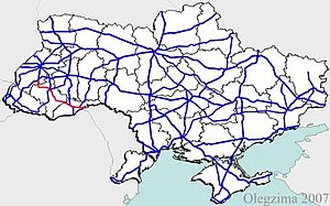
H10 is an important Ukraine national highway (H-highway) in Lviv, Ivano-Frankivsk, and Chernivtsi Oblasts.
History
[edit]H10 belonged to the Kingdom of Galicia and Lodomeria until 1918 and was known as the Beskydy Reichsstraße. In 1817, it was built as the second east-west connection leading from Bielsko-Biała to Chernivtsi and was initially referred to as the Carpathian Road.[1] In 1893, there were 21 toll booths on the 260-kilometer stretch between Stryi and Chernivtsi.[2]
The stretch from Stryi to Stanislaviv (former name of Ivano-Frankivsk) belonged to the territory of the Second Polish Republic between 1918 and 1939 and was declared a state road (droga państwowa) by the Polish Roads Act of 10 December 1920.[3]
See also
[edit]References
[edit]- ^ M. Stöger: Beschreibung der Karpathenstraße in Galizien. In: Oesterreichisches Archiv für Geschichte, Erdbeschreibung, Staatenkunde, Kunst und Literatur. Jg. 2, 1832, ZDB-ID 544634-x, S. 597–599, 603–604, 606–607.
- ^ Kundmachung der k.k. Finanz-Landes-Direktion in Lemberg vom 21. September 1892 Zl. 69.797, betreffend die Vermauthung der Aerarialstraßen in Galizien. LGBl. Nr. 73/1892, S. 181.
- ^ "Gesetz vom 10. Dezember 1920 über den Bau und die Erhaltung der öffentlichen Straßen in Polen. Dz.U. 1921 nr. 6 poz. 32". isap.sejm.gov.pl.

